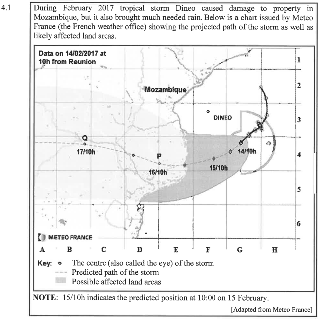
4.1.1 Dineo was classified as a Category I tropical storm with a maximum average wind speed of 95 miles per hour.
NOTE: 50 miles = 80,4672 km
Convert (rounded off to TWO decimal places) the maximum average wind speed to kilometers per hour. (3)
4.1.2 The distance between two vertical gridlines on the map is approximately 205,043 km.
Calculate, using the measured distance, the predicted average speed (in km/h) of the storm from point P to point Q.
You may use the following formula:


Use TABLE 6 and the graph on the ANSWER SHEET to answer the questions that follow.
4.2.1 Determine the missing value N. (2)
4.2.2 Draw another broken line graph on the ANSWER SHEET representing the total number of storms affecting the Western Pacific region from 2010 to 2015. (5)
4.2.3 Name the region that showed a downward trend in the number of storms experienced from 2010 to 2014. (2)
4.2.4 A news reporter compared the total cost of damage caused in the Western Pacific and North Atlantic regions to the total number of storms from 2011 to 2015. He stated that the more storms a region experienced, the greater the amount of the damage caused by them.
Verify (showing ALL calculations and give a reason) whether his statement is valid. (9)
4.3 In 2016 the Mozambican information department recorded the following data:
- Birth rate is 38,3 births per 1 000 population
- Death rate is J 1,9 deaths per 1 000 population
- Net migration rate is —1,9 migrants per 1 000 population
Determine Mozambique’s percentage population growth rate for 2016. (4)
[150]